Water is a vital natural resource for human survival and development, as well as an important restriction factor of the Eco-environment. Accurate quantitative water body recognition is crucial to many applications including environmental monitoring, resource survey, flood assessment, and drought detection. The presented research addresses a pervasive crucial concern, volumetric detection of water bodies.
Introduction
Accurate information on surface water is important for assessing the role it plays in urban ecosystem services in the context of human survival, climate change, and the hydrological cycle. Surface water refers to water on the surface of the Earth, such as a river, lake, wetland, and the ocean. Usually, the ocean is excluded in the definition due to its size and because it is salty, though smaller saline water bodies are usually included. Surface water bodies are critical freshwater resources, for both human and ecological systems. They are of paramount importance in sustaining all forms of life. Water helps preserve the biodiversity in riparian or wetland ecosystems by providing habitats to a plethora of flora and fauna. It is not only critical to the ecosystems as a key component of the hydrologic cycle but also touches every aspect of our lives, such as drinking water, agriculture, electricity production, transportation, and industrial purposes. Surface water bodies are dynamic as they shrink, expand, or change their appearance or course of flow with time, owing to different natural and human-induced factors. Variations in water bodies impact others’ natural resources and human assets and further influence the environment. Change in surface water volume usually causes serious consequences. The changes in urban water bodies make a huge difference to human lives and may cause disasters, such as surface subsidence, urban inland inundation, and health problems. In extreme cases, a rapid increase in surface water can result in flooding. Therefore, it is crucial to know about urban water distribution and changes in the water area to efficiently detect the existence of surface water, to extract its extent, to quantify its volume, and to monitor its dynamics. The spatial and temporal change pattern of the surface water has important practical significance and scientific value for water resources management, biodiversity, emergency response, and global climate change. Also, the precise extraction of surface water bodies is of great significance for urban planning, socio-economic development, urban environmental testing, urban heat-island effects, and urban ecosystem maintenance.
Overview of the Methodology
In recent years, satellite remote-sensing technology has developed rapidly and has the characteristics of a wide observation range, short return period, and so on. It has been widely used in many fields such as military reconnaissance, environmental protection, mapping, and geography. Among current urban water-extraction technologies, a mainstream method uses remote-sensing imagery to gather urban water information in a timely and accurate way. Previous urban water-resource surveys have been based on low- and medium-resolution images. However, small water bodies such as small ponds and narrow rivers cannot be extracted due to the limited spatial resolution of these remote-sensing images. With the improvement of the spatial resolution of remote-sensing images, many remote-sensing satellites (such as WorldView-2, IKONOS, and rapid eye) can provide high-resolution images. Most high-resolution remote-sensing images only have four bands (blue, green, red, and near-infrared), lacking the short-wave infrared (SWIR) data necessary to compute the modified normalized difference water index (MNDWI) and the automated water extraction index (AWEI) indices. A high-resolution spatial multi-spectral image has more detailed spatial features information, which can greatly improve the accuracy of urban water body extraction. Many algorithms have been proposed for identifying water bodies with remote-sensing imagery including single-band threshold and multi-band threshold methods, water body index methods, sub-pixel water mapping methods, and supervised and unsupervised classification methods. The water body index method has the characteristics of fast calculation and high precision, so it is widely used in practical applications. Modified Normalized Difference Water Index (MNDWI) which uses mid-infrared bands for normalization instead of near-infrared and green bands, and has better results for urban water body extraction. These improvements in the water index are generally difficult to apply in low-resolution remote-sensing images due to limited spectral resolution. Image classification methods such as supervised or machine learning are often used to extract water bodies from remote-sensing images. Generally, machine-learning methods include neural network and support vector machines, and unsupervised classification methods include k-means clustering and ISODATA clustering methods. The above algorithms are mainly used on low spatial resolution remote-sensing images. The existing algorithms have undergone less research for urban water body extraction in high-resolution satellite images. At present, the main problem for extracting an urban water body by low spectral resolution remote-sensing images is the ability to distinguish between the building shadows and the water bodies which is one of the most difficult tasks. Deep learning is the learning process that simulates the human brain. It can automatically extract high-level features from low-level features of the input image. For this project, a novel method for the extraction of urban water bodies based on deep learning is considered for high spatial resolution multispectral images. A new convolutional neural network (CNN)architecture is designed that can extract water and detect building shadows effectively even in complex circumstances and predict the superpixel as one of two classes including water and no water.
The major contributions are:
- A novel extraction method for urban water bodies based on deep learning is proposed for remote-sensing images. The proposed method combines the superpixel method with deep learning to extract urban water bodies and distinguish shadow from water.
- A new CNN architecture is designed, which can learn the characteristics of water bodies from the input data.
- To reduce the loss of image features during the process of pooling, we included self-adaptive pooling (SAP)
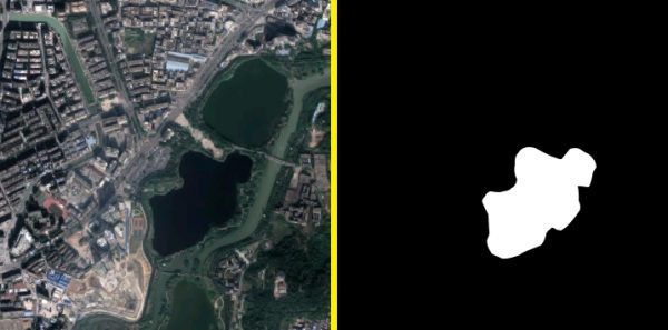
 Fig.1. Sample and Result
Technical Approach
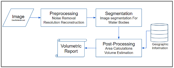
Using satellite images with resolutions better than 0.5m (GSD), an image segmentation model can be built. Image segmentation using ‘DeepConvolutional Neural Networks’ (D-CNN) is the method of classification of each pixel into predefined categories. For water body identification, an image-segmentation model can be developed, having two categories for each pixel, i.e. “Water” & “Others” classes. Finally, a pixel count and grouping mechanism can be developed which would count the ‘Water’ class pixels and hence calculate the total surface area on earth covered by water. An estimate of the water quantity can be guessed by combining the information related to the water body, such as average depth, the total volume of water present can be estimated.
 Fig.2. Water Bodies Detection: Architecture
Conclusion
In this project, a novel water body extraction method based on deep learning is proposed for high-resolution remote-sensing images. The proposed method combines an enhanced superpixel method with deep learning to extract urban water bodies and distinguishes between shadow pixels and water pixels. This study concludes that the proposed deep-learning methods can significantly improve urban surface water detection accuracy for the high-resolution remote-sensing imager


