Introduction
A combination of social, economic, legal, and administrative parameters leads, in several countries, to the stage of unplanned development and to the creation of a considerable number of illegal buildings.
When increased in number, they may create various problems such as:
- Decrease of state and local revenue since they are not fully taxed, as the illegal buildings are not registered, but they also demand additional infrastructure and services provision.
- Serious social and economic impact on the owners and on the national economy, and the real estate market. The owners may be charged with high penalties, also such properties cannot be transferred or mortgaged, while there is always a risk of creating an informal market, and
- In the case of a massive scale, they may have a negative environmental effect.
- The illegitimate nature of the buildings also poses a safety threat to the residents of the buildings and the people living near such illegally constructed buildings, as it is difficult to verify if the building was constructed following the Building Safety Codes of the region.
Governments have applied high penalties in case of the detection of illegal constructions, but this alone cannot solve the problem. Sound update of land-use planning according to changing needs, and a series of other fiscal and social measures are also necessary.
From a technical point of view, one common reason for the administration’s inefficiency to control unplanned development is the difficulty to locate quickly, and in time, the under-construction illegal buildings in a cost-effective way and stop the construction at its beginning or apply a penalty within a short time after its completion.
Classic administrative control procedures are proved inefficient, especially when public administration suffers from a lack of employees, bureaucracy, and increased responsibilities. It is difficult to place inspectors at each area to stop illegal construction work and this will encourage corruption.
The contribution of modern techniques and tools is necessary for the design of an automated and objective procedure for the detection of informal constructions.
The adjacent images show how the aerial view changes with time when the region is undergoing urbanization. Identifying these changes and matching them with municipal records can help in identifying illegal buildings.
Informal Settlements
- As per legal framework in most of the countries, “informal construction” is characterized by any construction which
* exists without a building permit,
* has any kind of excess or violation to the building permit,
* is in violation of any valid urban and spatial regulation regardless of the existence of a building permit. - The focus of this project is restricted only to the 1st category – constructions without a building permit- and on buildings at the urban fringe or generally in areas without urban plans, which gradually create unplanned settlements.
- The term “urban plan” refers to a formal set of rules and plans, which define the zoning and building regulations to be applied on both the private plots and the plots selected for common use and common benefit activities.
- In areas without urban plan construction is only permitted inland parcels bigger than 0.4 ha and only for a building size up to 200 sq.m.
- Also, these land parcels must not have been characterized as archaeological sites, forest land, environmentally sensitive areas, and they should not be under any other protection restrictions, e.g., those for coastal zones.
- Informal settlements in many countries do not have the characteristics of slums.
- The quality of construction and the living conditions in these areas are of a satisfactory or even high level.
- Also, illegal constructions have never created major conflict or violence with the state, mainly because they are built on legally owned land parcels.
- The lack of cadastre in such countries has a multidimensional impact on land management issues.
- It is the major factor that makes spatial planning procedure extremely time and cost consuming, and it allows the creation of informal settlements since there is no other tool available for environmental and development monitoring.
- Also, there is no other system for reliable statistical spatial data provided to support the development of land, the real estate market, and decision making for applying sound land use regulations and efficient land policy.
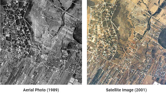
- The prior sample shows a rather typical example of unplanned urban sprawl in an area of Central Greece. This area is approx. 1.5 km from the sea and is characterized as agricultural land.
- Many land parcels though are small (most are under the minimum area size for a building permit) and gradually not cultivated.
- Until recently most construction there was exclusively for vacation purposes. The construction development in the sample area is observed in four different time periods.
- Aerial photos of years 1975, 1980, 1989, and a satellite image of 2001 are shown.
- All construction made before 1974 was legal, since the government, for a short period, gave permits for vacation houses in smaller parcels. The later government changed these regulations, to require all new construction to be on parcels of 4,000 sq.m or greater.
- The upper left area of the photos, with a dense road network, shows a part of the sample area which has a formal urban plan where development of land is permitted even inland parcels of an area size of 500 sq.m. All the remaining area is outside of the urban plan.
- Observation of the above four images shows that:
* In 1975 all area was agricultural land with very few buildings used for agricultural purposes. Very few vacation houses appeared due to the temporary governmental decision to permit this type of construction.
* In 1980 more buildings appear: those legal within the urban plan, where construction is comparatively larger and denser, and those informal within the ‘outside urban plan’ area.
* In 1989 almost all area within the formal urban plan has been developed legally. There is a significant development within the neighboring area where no urban plan exists; the majority of these buildings are informal, built without a building permit.
* In 2001 informal development within the area without urban plan becomes even denser. It is obvious that informal development was continued and it increased during the last decade and with even higher rates.
Available Platform and High-Resolution Data
- Today a wide variety of sensors and platforms is available, providing many choices of high-resolution imagery suitable for digital detection of buildings and other man-made constructions or physical elements.
- The scope of this project is the detection of illegal buildings, with a minimum area size of TBD (example -30 sq.m) and planimetric accuracy of the final photogrammetric product (vector plot or orthophoto) of TBD (example – 1m).
- Sensors that meet these technical specifications basically can be divided into two broad categories: airborne and spaceborne.
- Concerning airborne sensors, aerial cameras are the standard choice for very high-resolution imagery.
- Digital aerial cameras, in particular, are becoming popular since they have significant advantages over their film-based predecessors. These cameras:
* ensure a continuous digital workflow from data acquisition to data processing, and
* are not influenced by grain and usually have better radiometric resolution than film cameras. - Spaceborne sensors are also a good source for high-resolution image data. Satellite images may have lower ground resolution than aerial images, but they cost less and each scene covers a larger area.
- Very high-resolution spaceborne systems like IKONOS-2, QuickBird-2, and OrbView-3 provide panchromatic images with 0.82m, 0.62m, and 1m ground resolution, for nadir view, respectively.
- New generation satellites like EROS-C, OrbView-5, and WorldView-1 provide a higher ground resolution of about 0.4m-0.7m, and real-time transmission of imagery, making spaceborne systems even more attractive.
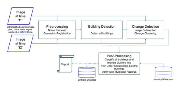
Change Detection Strategies
- Monitoring the suburban environment for illegal buildings is, in fact, a change detection problem augmented by some spatial information concerning land use zones and building regulations. The solutions proposed to the problem depend on the image scale.
- For monitoring illegal urbanization, first, buildings are extracted and then they are back-projected to the reference data where it is determined if there has been a change.

- The prior sample shows a rather typical example of unplanned urban sprawl in an area of Central Greece. This area is approx. 1.5 km from the sea and is characterized as agricultural land.
- Many land parcels though are small (most are under the minimum area size for a building permit) and gradually not cultivated.
- Until recently most construction there was exclusively for vacation purposes. The construction development in the sample area is observed in four different time periods.
- Aerial photos of the years 1975, 1980, 1989, and a satellite image of 2001 are shown.
- All construction made before 1974 was legal, since the government, for a short period, gave permits for vacation houses in smaller parcels. The later government changed these regulations, to require all new construction to be on parcels of 4,000 sq.m or greater.
- The upper left area of the photos, with a dense road network, shows a part of the sample area which has a formal urban plan where development of land is permitted even inland parcels of an area size of 500 sq.m. All the remaining area is outside of the urban plan.
- Observation of the above four images shows that:
* In 1975 all area was agricultural land with very few buildings used for agricultural purposes. Very few vacation houses appeared due to the temporary governmental decision to permit this type of construction.
* In 1980 more buildings appear: those legal within the urban plan, where construction is comparatively larger and denser, and those informal within the ‘outside urban plan’ area.
* In 1989 almost all areas within the formal urban plan has been developed legally. There is a significant development within the neighboring area where no urban plan exists; the majority of these buildings are informal, built without a building permit.
* In 2001 informal development within the area without urban plan becomes even denser. It is obvious that informal development was continued and it increased during the last decade and with even higher rates.
Available Platform and High-Resolution Data
- Today a wide variety of sensors and platforms is available, providing many choices of high-resolution imagery suitable for digital detection of buildings and other man-made constructions or physical elements.
- The scope of this project is the detection of illegal buildings, with a minimum area size of TBD (example -30 sq.m) and planimetric accuracy of the final photogrammetric product (vector plot or orthophoto) of TBD (example – 1m).
- Sensors that meet these technical specifications basically can be divided into two broad categories: airborne and spaceborne.
- Concerning airborne sensors, aerial cameras are the standard choice for very high-resolution imagery.
- Digital aerial cameras, in particular, are becoming popular since they have significant advantages over their film-based predecessors. These cameras:
* ensure a continuous digital workflow from data acquisition to data processing, and
* are not influenced by grain and usually have better radiometric resolution than film cameras. - Spaceborne sensors are also a good source for high-resolution image data. Satellite images may have lower ground resolution than aerial images, but they cost less and each scene covers a larger area.
- Very high-resolution spaceborne systems like IKONOS-2, QuickBird-2, and OrbView-3 provide panchromatic images with 0.82m, 0.62m, and 1m ground resolution, for nadir view, respectively.
- New generation satellites like EROS-C, OrbView-5, and WorldView-1 provide a higher ground resolution of about 0.4m-0.7m, and real-time transmission of imagery, making spaceborne systems even more attractive.
Change Detection Strategies
- Monitoring the suburban environment for illegal buildings is, in fact, a change detection problem augmented by some spatial information concerning land use zones and building regulations. The solutions proposed to the problem depend on the image scale.
- For monitoring illegal urbanization, first, buildings are extracted and then they are back-projected to the reference data where it is determined if there has been a change.
Illegal Urbanization Detection: Architecture
New Building Detection
- New buildings can be identified from the combination of building detection and change detection solutions.
- Buildings identified in both images can be verified to be existent on municipal records, to determine their legitimateness.
- This use case mostly relies on building detection and takes help from the change detection algorithm.
Illegal Building Detection Using AI
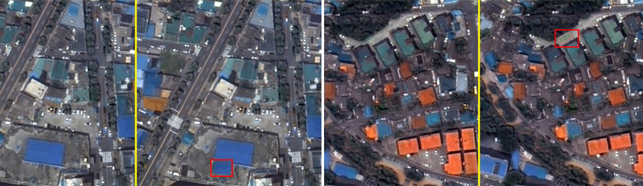
- NEW ILLEGAL BUILDING UNDER CONSTRUCTION
New buildings can be identified from the combination of building detection and change detection solution.
Buildings identified in both images can be verified to be existent on municipal records, to determine their legitimateness.
This use case mostly relies on building detection and takes help from the change detection algorithm. - ILLEGAL BUILDING EXTENSION
Extension to buildings can be detected using the changes in the area of the bounding box of the building combined with the change detection obtained difference image.
An information classifier can be built to classify these changes as to they indicate building an extension or not.
Municipal records can help in identifying if an extension is within the permissible range.
This solution is an equal application of both, building detection and change detection algorithm. - ILLEGAL CONSTRUCTION OF RECREATIONAL AREAS
The construction of open-air recreational areas can be identified from the AI-based change detection solution.
Changes in the images over time can be classified as changes in the landscape, which can be further enhanced by Sports Facilities detection, and any other specific object detection solution.
This use case is a direct application of change detection and can be further enhanced using various other object detection techniques.
Conclusion
- Using satellite images and data available from the municipal records, our platform provides an automated procedure that is easy to use, robust, and accurate enough, to meet the needs of specific purposes.
- It benefits from the modern “know-how” in the monitoring of changes and in automatic building extraction using high-resolution images.
- Administratively, the proposed system may be easily applied at a regional level, without significant requirements for state acts, e.g., the new legal framework.
- It is cost-efficient taking into consideration the benefits of solving the problem of loss of state revenue and the impact on the national economy such in-formalities bring until the necessary reforms will be in place.